Rigdon

SWFC Director Interviewed for Local Podcast

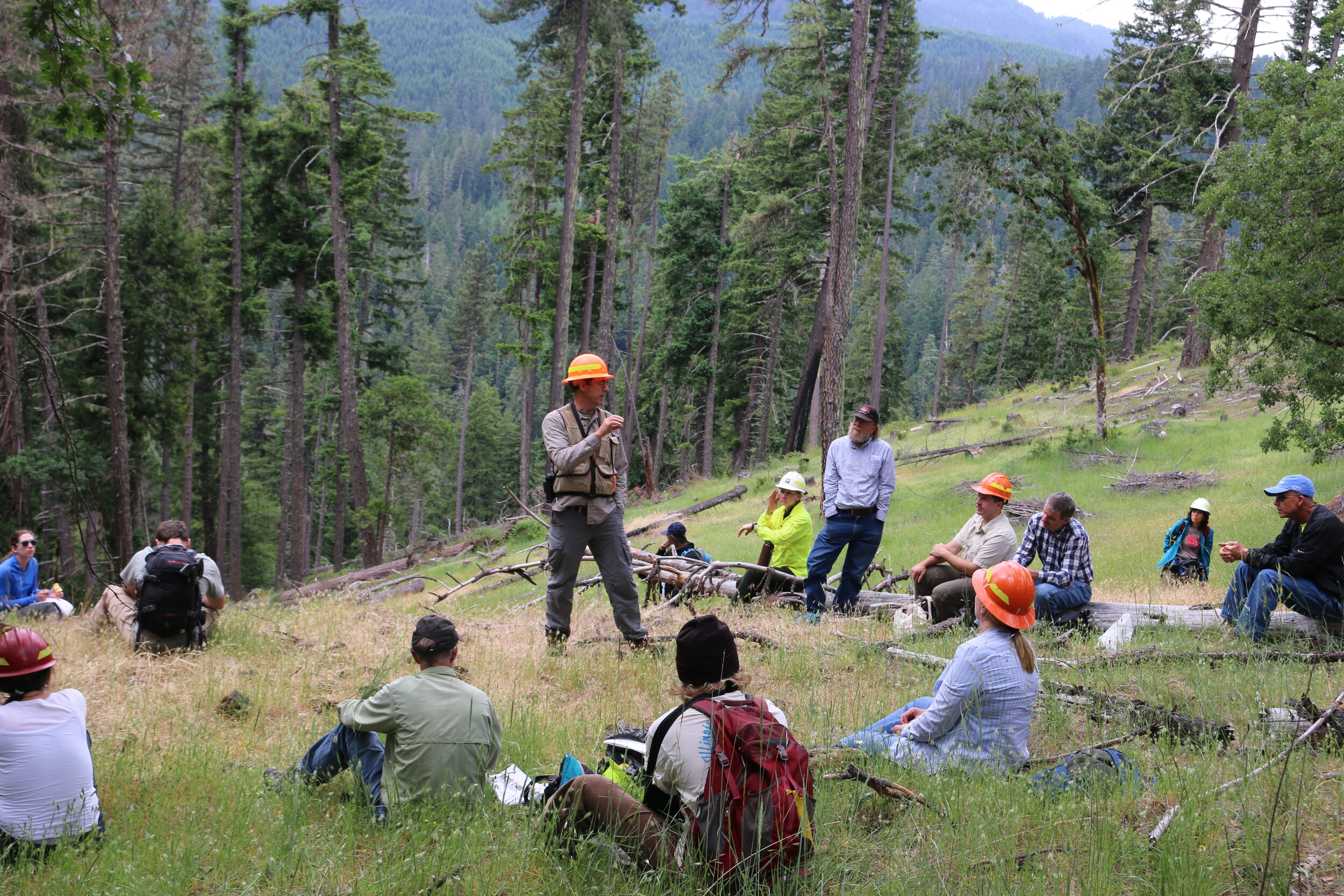
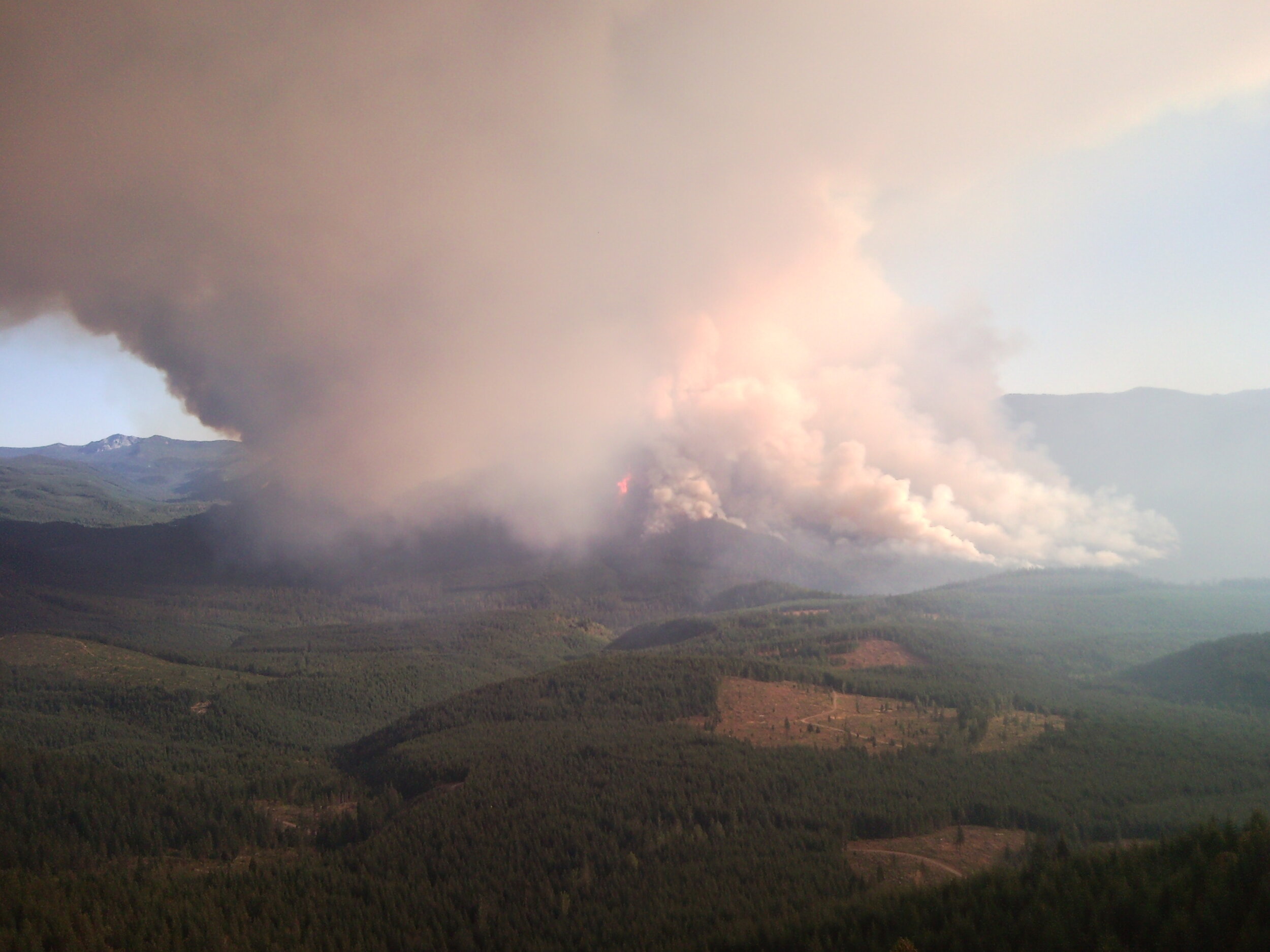
SWFC Director Sarah Altemus-Pope recently sat down with EugCast podcast host Jojo Jensen to talk about wildfires, restoration, and the Rigdon landscape. Sarah shares her perspectives on living with fire, increasing the pace and scale of restoration, and the value of shared learning. She also talks about what may be in the works for Rigdon and future projects, especially as Covid restrictions are lifted. The episode is a great introduction to the work of the Southern Willamette Forest Collaborative for newcomers as well as for folks who could use a refresher on the projects the SWFC is involved with.

EugCast is a volunteer-run conversational podcast based in Eugene, Oregon. Monthly episodes feature guests from Eugene and the surrounding areas discussing a broad range of topics. In addition to Sarah’s episode, collaborative members may be interested in the March 2020 interview with Ian Appow, who coordinates the Wildfire Urban Interface Fuels Reduction Project. Ian has been engaged with Firewise efforts in and around the Oakridge-Westfir community.

Take a Self-Guided Field Trip of Youngs Rock Rigdon

Take a Self-Guided Field Trip of Youngs Rock Rigdon

Updated December 15, 2020

IMG_5403 (1).JPG

The Willamette National Forest’s Middle Fork Ranger District (MFRD) and the Southern Willamette Forest Collaborative (SWFC) have worked together for four years to develop the Rigdon Landscape Analysis and conduct environmental analysis for an area southeast of Oakridge, Oregon. Fire suppression has dramatically changed the composition of the landscape. The project provides a critical opportunity to move the landscape towards more historical conditions that supported dry mixed conifer forests, diverse indigenous floral understories, Oregon white oak, ponderosa pine, ungulates, monarch butterflies, bull trout, and salmon habitats.

In 2016, the Forest Service interdisciplinary team (IDT) started an in-depth process to assess the ecological systems and identify landscape objectives to create proposed actions. The SWFC Rigdon Collaboration Committee (RCC) - which includes members from the local communities, watershed council, timber industry, recreation and special interest groups, and state and local agencies - formed to engage in the pre-planning process.

National Forest Foundation Community Capacity and Landscape Stewardship Program funding helped the RCC host shared learning opportunities, field trips, and roundtable discussions between the IDT and committee members. The collaborative committee developed landscape-level zones of agreement for the Forest Service to consider in drafting the Rigdon Landscape Analysis and future proposed management actions.

Developing a more thorough understanding of the area’s fire history has led to more informed and complete plans for restoration and monitoring. Funding from the Oregon Department of Forestry and Good Neighbor project revenue enabled SWFC to engage researchers from Oregon State University (OSU) and the University of Oregon (UO). 

IMG_5365.jpg

Bart Johnson, from the UO School of Architecture, is conducting post-implementation monitoring of a 600-acre pilot project to promote Oregon white oak savanna through thinning, reseeding, and subsequent prescribed fire treatments. James Johnston, from the OSU dendrochronology lab, analyzed the fire frequency on the Rigdon Landscape over the past 400+ years, revealing that some areas burned as frequently as every four years while higher elevation stands often went hundreds of years without burning. These findings have helped partners and the agency better understand how to implement restoration activities that lead to a more fire-resilient landscape.

IMG_5367.JPG

The first Rigdon Landscape project, Youngs Rock Rigdon (YRR), is an environmental impact statement scheduled for a record of decision in 2021. Implementing YRR restoration activities with Stewardship and Good Neighbor Authority tools will create a more resilient landscape as climate conditions change, help ensure more restoration within treatment areas over time, and support the local economy. 

The SWFC created a suite of resources to encourage participation in the Rigdon project, including a self-guided field trip of the area using the free Avenza app. You can download the field trip packet, maps, and field trip layer here.

The SWFC also worked with the Forest Service to create a Rigdon StoryMap providing in-depth context about the history and value of the landscape and details about restoration plans, and a video of key stakeholders sharing their perspectives on the project (coming soon). The SWFC highlighted perspectives ranging from timber workers to environmental advocates in a blog series earlier this year.


IMG_5215.jpg

July 16, 2020

If you haven't had a chance to make it to a public field trip or just want to investigate the project area at your own pace, you can now take a self-guided field trip using the Avenza app. This tool allows you to learn about the proposed actions related to aquatics, vegetation, wildlife, and human uses for the first project within the larger Rigdon landscape. The app includes geo-located stops, descriptions, and images from the Forest Service and SWFC. Instructions for both Android and iOS are available in the handout below.

Taking a self-guided field trip to the area is a great way to learn about the Youngs Rock Rigdon project scope and plans for restoration. The project's initial public comment phase just wrapped up with a second anticipated in the fall as part of the NEPA process, so this summer is an ideal time to visit the site. Getting to the project area involves a 50-minute drive southeast of Oakridge on Forest Service Road 21.

If you have questions about using Avenza or the field trip files, please contact Sarah Altemus-Pope at director@swfcollaborative.org

Learn About the Rigdon Landscape Project Through Our Guest Blog Series

Through multiple guest blog series, our partners have helped us tell the story of the Rigdon Landscape Project!

We formed the Rigdon Collaboration Committee in 2016 to work with the Forest Service on the Rigdon Landscape Project. We facilitated learning sessions, field trips, and roundtable discussions. After education sessions concluded, the group transitioned to roundtable discussions. This allowed committee members provided feedback to the Forest Service Interdisciplinary Team for future actions.

About the Landscape
The Rigdon landscape encompasses four Middle Fork Willamette sub-watersheds south of Oakridge, Oregon. Over the years, climate and fire have maintained mixed conifer forests and scattered wet and dry meadows. This landscape provides habitat for spring chinook, bull trout, and the northern spotted owl. Historical native tribes occupied this area and prescribed low intensity fires every 5-10 years. Over the last 150 years fire suppression has created dense forests. As a result the landscape has become less resilient and prone to high intensity wildfires.

About the Project


Rigdon Fire History

What Rigdon Means to our Partners

Rigdon Monarchs & Meadows

What Rigdon Means to Me: Seneca Sawmill


Guest Blogger: Kevin Tuers


Southern Willamette Forest Collaborative Participation:  I have been participating in the Southern Willamette Forest Collaborative since 2016.  I was introduced to the SWFC by being on the Middle Fork Willamette Watershed Council Board of Directors. 

Envisioning a Healthy Rigdon Landscape

A healthy Rigdon Landscape has a variety of habitats that is suited for all species of plants and animals and resilient to catastrophic fires.  This healthy landscape would have the variety and diversity that can be enjoyed by all.

The Rigdon landscape encompasses four Middle Fork Willamette sub-watersheds south of Oakridge, Oregon. Click the map to the right to enlarge.

 
D_Peak1988.jpg

Visiting the Rigdon Landscape

I started recreating on the Rigdon landscape in 1988 when I was 13 years old camping and deer hunting, this was the year I shot my first buck.  You can see Diamond Peak in the Background.

I have continued to recreate for the past 32 years in the area almost every fall.  In 2006 I landed a job with Seneca Jones Timber Company based out of Eugene Oregon.  Seneca owns 21,400 Acres within the Upper Middle Fork Willamette Watershed and many of these acres are located within the Rigdon Landscape.  I am the GIS/Inventory Forester and have the pleasure of spending much of my work time in this area.

Changes Throughout the Years

The landscape has definitely changed since 1988, with the change in the forest practices by the USFS, Catastrophic fires and lack of fire presence in certain areas. These changes have led to some less than ideal habitat conditions for a variety of species.


Favorite Memory

I have many great memories of this area, but one of my favorites is taking my children huckleberry picking in the fall for the first time and watching them enjoy the fruits of nature!

DSC00011.jpg

Favorite Areas

diamondpeak.jpg

Bear Ridge has always been one of my favorite areas in the Rigdon Landscape, it has a variety of different habitats as it extends down from Diamond Peak.


Restoration Opportunities

SNC00375.jpg

I am most excited about the fuels reduction program on the landscape and reducing the risk of catastrophic wildfire.  I was on the Tumblebug Fire in 2009 and watched how it devastated thousands of acres in minutes.

Final Thoughts

I work and recreate in the Rigdon Landscape and have viewpoints from a variety of positions.  Growing trees for today and the future is our goal and is an investment we wish to protect.  This also creates a distributions of habitats on our lands within the landscape while providing jobs and economic benefits for the local communities.  As a recreationalist in this area I look forward to the habitat and landscape projects that will help diversify and help this landscape flourish.


Kevin his Daughter Aiden and pal Keta (Oncorhynchus keta) Dog Salmon

Kevin his Daughter Aiden and pal Keta (Oncorhynchus keta) Dog Salmon

Kevin Tuers is a 6th generation Oregonian whose family has been in the timber industry for many years.  Kevin Graduated Oregon State University in 1997 with a Forestry and Wildlife Science Degree.  He has over 25 years of Forestry experience in Oregon and California. Kevin is an avid outdoorsman and enjoys camping and fishing but especially has a passion for hunting Elk and Deer in the fall.


What Rigdon Means to Me: Oregon Department of Fish & Wildlife


Guest Blogger: Oregon Department of Fish & Wildlife Representative


Southern Willamette Forest Collaborative Participation:  I have participated in the Southern Willamette Forest Collaborative for many years in various capacities. The collaborative provides a constructive platform for diverse groups, agencies, and members of the public to share ideas and prospective in a respectful and productive atmosphere.

Envisioning a Healthy Rigdon Landscape

A healthy Rigdon landscape supports the type of habitat that should be there under natural ecological processes. These natural processes have been altered by conflicting land management activities and the interruption of natural processes. In the long term healthy, naturally functioning ecosystems will be less expensive to maintain and more resilient to anticipated climate change.

The Rigdon landscape encompasses four Middle Fork Willamette sub-watersheds south of Oakridge, Oregon. Click the map to the right to enlarge.

Visiting the Rigdon Landscape

I have both worked and recreated within the Rigdon Landscape for over 17 years. My professional involvement with the Rigdon project began in 2006 long before it was called Rigdon.

Changes Throughout the Years

Many of the large pine and oak trees we are trying to conserve have died since I began working on this project before it was called Rigdon. Semi‑open pine and oak stands have also been invaded by regenerating Douglas‑fir trees, exerting additional stress on the remaining pine and oaks. The shrub and forb understories are converting to barren areas of needle cast. Wildlife associated with pine and oak habitat are also diminishing. The remaining pine and oak habitats in the Rigdon project area will be lost if this project is not implemented.

IMG_5126.jpg

Favorite Memory

My favorite memory in the Rigdon area was seeing the positive response of pine and oak associated plant and wildlife species to the restoration conducted at Jim’s Creek. This gives me hope that we can accomplish similar responses on a landscape scale.

Favorite Areas

My favorite area in Rigdon is the Jim’s Creek Project demonstration area. The Jim’s Creek area is approximately 400 acres where the Forest Service restored pine and oak habitat by manipulating vegetation and restoring fire to the landscape. Native shrub, forb, and grass planting occurred, but many of these species responded naturally from the dormant seed bed. Jim’s Creek showed me what habitat was on this landscape for hundreds or more years. Restoring this habitat is possible and will produce a landscape more resilient to expected climate shifts in the future.

IMG_5382.JPG

Restoration Opportunities

IMG_5597.JPG

From a wildlife and wildlife habitat perspective, I am most interested in the pine, oak, and prairie restoration components of the project. Loss of these habitat types has occurred on a large scale in the southern Willamette Valley. The proposed road closures and decommissioning will also added needed security for wildlife from disturbance, as well as, assist restoration of some interrupted hydrologic processes. Finally, the proposed floodplain restoration will provide quality riparian habitat for numerous riparian associated and dependent species. Most riparian areas located on our national forests currently lack the structural and vegetative components necessary to support wildlife associated and dependent species that rely on this habitat type.


IMG_5515.JPG

THE AUTHOR OF THIS BLOG HAS ELECTED TO REMAIN ANONYMOUS.


Story Map: Rigdon Landscape Restoration Project

The Southern Willamette Forest Collaborative and the Middle Fork Ranger District worked together to create the Rigdon Landscape Restoration Project Storymap. This blog includes a brief overview of information provided in the Storymap, click the link below to see the full project.


Overview: The Rigdon Landscape Restoration Project Storymap gives you information on the location of the project, historic conditions, changes over time, the planning and collaboration process, and the proposed treatments.

Storymap Link: https://storymaps.arcgis.com/stories/6e12f4172f89410da989d205b14e926a

The Rigdon landscape encompasses an area south of Oakridge, Oregon within the Headwaters of Middle Fork Willamette River. This area, 104,000 acres in size, is surrounded by the High Cascades to the east and the Calapooya Mountains to the west and so…

The Rigdon landscape encompasses an area south of Oakridge, Oregon within the Headwaters of Middle Fork Willamette River. This area, 104,000 acres in size, is surrounded by the High Cascades to the east and the Calapooya Mountains to the west and south.

Rigdon Monarchs & Meadows: Milkweed in Rigdon


Guest Blogger: Kris Elsbree


Milkweed in Rigdon

The Rigdon Area in the Southern end of the Willamette National Forest is a dry mixed conifer forest that holds the northern extent of several species giving an oasis nestled in the Upper Willamette Watershed. 

Some of the unusual botanical characteristics include the abundance of Oregon White Oak and East side variety of Ponderosa Pine.  Taking a closer look at the plant communities in the meadows of this region and a distinct area can be defined as a habitat more likely to be found Southern Oregon. 

Field Crew with large Oregon White Oak on Milkweed Ridge 2018

Field Crew with large Oregon White Oak on Milkweed Ridge 2018

One of the most picturesque and defining species to this habitat is Asclepias Cordifiolia; heart-leaf milkweed.  Coming to full bloom in late June and July heart-leaf milkweed becomes the center point of several meadows in the area being the largest plants with stunning flowers and seed pods. 

Monarch larva on heart-leaf milkweed 2018

Monarch larva on heart-leaf milkweed 2018

Only a few years ago as the Rigdon Landscape analysis was underway there was only three known populations of milkweed in the Rigdon Area.  Tanya Harvey; a member of the Oregon Native Pant Society and the North American Butterfly Association and co-author of the Oregon Flora Volume 2; began looking at more potential sites for milkweed. 

Not only was Tanya able to find more milkweed but also discovered the first monarch butterfly in the area.  Since then Walama Restoration Project in Partnership with the U.S. Forest Service has been aiding those efforts by conducting milkweed and monarch butterfly surveys. 

Heart-leaf milkweed with seed pods

Heart-leaf milkweed with seed pods

To date 16 meadows have been documented with milkweed and monarch butterflies.  The Western migration of Monarch butterflies is not completely understood, and the population has decreased over 90%.  This new known habitat may be a prime steppingstone for their migration and this new data will help the Forest Service better plan and implement projects to expand habitat for monarch butterflies and other pollinators and wildlife that share this habitat.

Fifth instar monarch caterpillar 2018

Fifth instar monarch caterpillar 2018


Kris.jpg

Kris Elsbree is the crew leader for Wallama Restoration Project, hails from upstate New York.  In his early days, Kris worked to create and maintain George V Vanderbilt Park.  Chris attended Lane Community College and was President of the Lane Community College Learning Garden.  Working with Walama since 2008, Kris excels in the leadership skills and field knowledge necessary to guide the crew an land contracts.


Rigdon Monarchs & Meadows: Monarchs in Rigdon


Guest Blogger: Tanya Harvey


Below is an excerpt from Tanya Harvey’s blog, follow the link to read the full article: A Week of Monarchs and Milkweed: Day 1 . Banner photo courtesy of Tanya Harvey.

Monarchs in Rigdon

Photo credit: Tanya Harvey. Female monarch nectaring on milkweed.

Photo credit: Tanya Harvey. Female monarch nectaring on milkweed.

“We decided to access the area via an old road off of Road 2135, just past Big Pine Opening. A short bushwhack off the old road took us up to the south and lower end of the meadow complex (although we found an easier route back through more open woods on the way back). It only took a few minutes for us to spot the first monarch and the first caterpillar. Almost a week from when Sabine and I saw eggs at Monarch Meadow, it was about the right time for the eggs to start hatching.

We set about counting eggs, caterpillars, and adults in each opening. Crystal kept a count and recorded information about habitat while I took photos and put together a preliminary plant list. At this point in the year and less than 3000′ of elevation, most things were dried out, and even the milkweed was mostly beginning to go to seed, so I’m sure there will be many more plants to add to the list that we didn’t spot that day. What we did see looked pretty much the same as what was growing in Monarch Meadow, with the exception of a population of field pussytoes (Antennaria howellii), a species I’ve seen much higher up near Balm Mountain (see Another Exciting Day in the Calapooyas: The Sequel) and in one higher elevation spot in Douglas County.”


Tanya Harvey.jpg

Tanya Harvey is an amateur botanist and gardener who has been in love with plants as long as she can remember. Officially, she’s an artist, craftsperson, and designer (check out her work at tanyaharveydesign.com).

With the Western Cascades as her backyard, she spend as much time as she can botanizing the Western Cascades and, in the interests of science, conservation, and beauty, she shares what she learns through her website (westerncascades.com).

Tanya is also a member of the Oregon Native Pant Society and the North American Butterfly Association and co-author of the Oregon Flora Volume 2.


Rigdon Monarchs & Meadows: Meadows in Rigdon


Guest Blogger: Tanya Harvey


Below is an excerpt from Tanya Harvey’s blog, follow the link to read the full article: Further Rigdon Area Meadow Exploration. Banner photo courtesy of Tanya Harvey.

Meadows in Rigdon

Photo credit: Tanya Harvey. Mating fritillaries on mock orange. Checkerspots, Lorquin’s admirals, and a pale swallowtail also took advantage of the abundant nectar, while I enjoyed the heady fragrance.

Photo credit: Tanya Harvey. Mating fritillaries on mock orange. Checkerspots, Lorquin’s admirals, and a pale swallowtail also took advantage of the abundant nectar, while I enjoyed the heady fragrance.

“I headed up the steep slope and through the woods to locate the waypoint Crystal had given me. I was not very hopeful as I really couldn’t imagine that there were any appropriate openings. But then I found the little sunny spot with some outcrop at the base, and there was the milkweed! It was only about a half-acre, but it had several fully blooming mock orange (Philadelphus lewisii) shrubs at the base of the rocks, attracting many butterflies and other insects.

While there weren’t very many large milkweed plants, a thorough survey totaled 37 plants, including 7 seedlings. Hard to imagine but it appeared that this population was expanding. I knew this species like shadier edges of rocky meadows, but I never imagined it could survive in such a small sunny spot. What really surprised me was that I found 2 monarch eggs and one (sadly) dead caterpillar on the ground beneath a milkweed plant. How did they find such a small population in such a small opening?! I’m calling this little spot Crystal’s Glade, and I definitely plan to revisit it in the future to see how the population is doing.”


Tanya Harvey.jpg

Tanya Harvey is an amateur botanist and gardener who has been in love with plants as long as she can remember. Officially, she’s an artist, craftsperson, and designer (check out her work at tanyaharveydesign.com).

With the Western Cascades as her backyard, she spend as much time as she can botanizing the Western Cascades and, in the interests of science, conservation, and beauty, she shares what she learns through her website (westerncascades.com).

Tanya is also a member of the Oregon Native Pant Society and the North American Butterfly Association and co-author of the Oregon Flora Volume 2.


What Rigdon Means to Me: Middle Fork Willamette Watershed Council


Guest Blogger: Sarah Dyrdahl


Pre-project Staley Creek Tour with USFS, SWFC, and MFWWC. Spring 2017

Pre-project Staley Creek Tour with USFS, SWFC, and MFWWC. Spring 2017

Southern Willamette Forest Collaborative Participation:  I have been an active member since 2016. I am currently an ex-officio, non-voting board member and I regularly participate on the Implementation Advisory Committee and the Rigdon Collaboration Committee.


Envisioning a Healthy Rigdon Landscape

Rivers and forests where ecosystem processes are preserved with land management, recreation, and other uses. Clean water and abundant fish and wildlife populations.  Patch complexity across the landscape where there’s a diversity of habitat types – wild rivers, meadows full of wildflowers and pollinators, fire, healthy forests, and beautiful views.

The Rigdon landscape encompasses four Middle Fork Willamette sub-watersheds south of Oakridge, Oregon. Click the map to the right to enlarge.


Visiting the Rigdon Landscape

Sarah, Audrey Squires (project manager), and Meta Loftsgaarden (executive director of the Oregon Watershed Enhancement Board) tour the post-project Staley Creek floodplain. Spring 2018

Sarah, Audrey Squires (project manager), and Meta Loftsgaarden (executive director of the Oregon Watershed Enhancement Board) tour the post-project Staley Creek floodplain. Spring 2018

I began working for the Middle Fork Willamette Watershed Council in 2015 and the first restoration project we developed was the Staley Creek Floodplain Restoration Project in partnership with the US Forest Service Aquatics Team.  We implemented that project in 2017 and began developing the Coal Creek Floodplain Restoration Project, which was implemented in 2019.  We’re still working on building the Middle Fork Trail re-route as part of that project and expect it to be completed summer 2020.

Sugar Pine Cone

Sugar Pine Cone

Before coming to the Middle Fork, I had never recreated in the Rigdon Landscape, but to do my job well, it’s imperative that I know the watershed intimately.  That need led to a crash course in recreating in the Rigdon area, which has been incredible.  I’d spent the last 10 or so years working in agricultural landscapes in the mid-Willamette Valley and on the Oregon coast and was instantly drawn to Rigdon because of its feeling of rugged wildness (and limited crowding), as well as forests more reminiscent of where I grew up in southern Oregon.  There are even sugar pines which are home to me.

Jims Creek

Jims Creek

Changes Throughout the Years

The changes I notice are the active restoration actions that my organization and our partners are responsible for – the two floodplain restoration projects, a trail re-route of the Middle Fork Trail, the burning at Jim’s Creek. Other noticeable changes that aren’t human-caused are new river meanders and the activation of new and different side channels.

Favorite Memory

I can share a least favorite memory!  Early in my explorations of Rigdon, I made the mistake of trying to hike the trail from Jim’s Creek to Moon Point in early summer.  About ¾ of the way up, my poor dog and I were completely engulfed by voracious mosquitos.  I looked like the character Pig Pen from Charlie Brown – but instead of dirt, it was a swarm of mosquitos.  My poor dog had a look of remorse on her face. Long sleeves and pants did nothing to mitigate their attack.  Instead of hiking as intended, I was running the trail – in hiking boots, with my daypack.  It was the most miserable time!  We recovered on the Middle Fork Trail where the mosquitos were almost absent. 


Favorite Areas

Fall Views from Maple Creek

Fall Views from Maple Creek

My favorite area depends on my mood.  There are many favorites – the vista and views from the top of Maple Creek in the fall when the Middle Fork and tributaries are a bright gold ribbon of color. (right)

If you squint into the center of this photo, you can see the Coal Creek project. Taken from the top of Jim's Creek.

If you squint into the center of this photo, you can see the Coal Creek project. Taken from the top of Jim's Creek.

The uppermost meadow at Jim’s Creek where I can sit on a sunny south-facing slope and see the Coal Creek Floodplain Restoration Project and watch turkey vultures ride the air currents for as long as the daylight lasts. I enjoy the sweet smell of the warm forest on a sunny day. (lower right)

I also enjoy regular, unstructured explorations of the Staley Creek floodplain project – to look at the active changes that are occurring there.  Rainstorms offer moments of anticipation and a learning opportunity to understand how the river interacts with and sculpts its floodplain.  Grasses, sedges, rushes, and other woody plants are emerging; cobbles, rocks, sands, and logs are sorting; and big, deep pools are forming.  Water moves in almost every direction, at varying depths.  I don’t often seen critters when I’m out, but know they’ve been there from the beaver chewed sticks to the tiny prints of what I’m betting is a river otter. 

Exploring the Staley Creek floodplain post-project

Exploring the Staley Creek floodplain post-project

Life after disturbance: native plants come back

Life after disturbance: native plants come back


Restoration Opportunities

Coal Creek fish rescue crew

Coal Creek fish rescue crew

I am most excited about a landscape scale restoration vision and approach that pairs upland and floodplain restoration – opening up meadows and dry-mixed conifer forests and using some of that wood to restore nearby rivers and floodplains.  Learning how to manage the landscape with fire – both controlled burns and natural ignitions – will be essential.  If we can work to reduce fuel loads in the uplands, fire can become our friend, not our foe. 

We know this landscape has seen human use and interactions long before white settlers arrived.  I envision restoration actions that incorporate and engage the community – where the community has a sense of ownership over the work – and a connection to the place.  Community volunteers have worked with us to rescue fish at our floodplain restoration project.  Volunteer trail crews cleared and built new sections of the Middle Fork Trail.  High school students have helped us imagine interpretive signage.  Connecting our community to the land and water is one the most satisfying aspects of my work.

A member of Twin Rivers Charter School finds balance on a Coal Creek pre-project floodplain stump.

A member of Twin Rivers Charter School finds balance on a Coal Creek pre-project floodplain stump.

A Twin Rivers Charter School student tests out the restored Staley Creek floodplain

A Twin Rivers Charter School student tests out the restored Staley Creek floodplain

A Twin Rivers Charter School student makes temporary art in the floodplain

A Twin Rivers Charter School student makes temporary art in the floodplain


Sarah with her pal Keta.

Sarah with her pal Keta.

Sarah Dyrdahl became the executive director of the Middle Fork Willamette Watershed Council in August 2015. Sarah has been working on rivers in Alaska and Oregon since 2004, including significant experience building and managing restoration programs for four additional watershed councils in Oregon – Coos, Calapooia, South Santiam, and North Santiam. Before migrating upstream to freshwater ecosystems, Sarah studied nearshore marine ecological communities along the Oregon Coast with the Partnership for Interdisciplinary Studies of Coastal Oceans.

Sarah grew up in the country, on the banks of the Applegate River in southern Oregon – an experience that she weaves into her dream job of conserving and restoring rivers and landscapes through community building. When not working in the Middle Fork Willamette, Sarah can be found out exploring and enjoying the many beautiful watersheds of Oregon – on foot or by boat.


What Rigdon Means to Me: Back Country Horsemen


Guest Bloggers: Back Country Horsemen Representatives


Southern Willamette Forest Collaborative Participation: 3 + years.

Envisioning a Healthy Rigdon Landscape

The Rigdon landscape encompasses four Middle Fork Willamette sub-watersheds south of Oakridge, Oregon. Click the map to enlarge.

A healthy Rigdon landscape would include: natural meadows, a mature varied-species forest, clean air and water, a safe balance among all trail users, a well-maintained Middle Fork Willamette (MFW) trail, adequate designated parking for horse trailers at trail entry points, and more regulated, designated opportunities for camping, including camping for horses.

A major opportunity we are happy to contribute to, is increased bull trout populations and  family fishing potential. Our Back Country Horsemen (BCHO) commitment to this area goes beyond just equine trail use. We have donated money and time on bridges over sensitive wetlands and bogs along the trail, helping to mitigate sediment flows.  


Visiting the Rigdon Landscape

513188-R1-15-15A.JPG

We have worked and recreated on the Middle Fork Willamette (MFW) trail for 25 years. We’ve ridden horses and maintained trails throughout the years, to include being responsible for Keele Crossing cedar puncheon (built in 2005.) Through Back Country Horsemen (BCHO), we have helped maintain the MFW Trail for 20 years and contributed funding for rebuild of several bridges on MFW trail.

Changes Throughout the Years

We’ve seen changes due to significant mountain bicycle pressure on the MFW trail. Some of our group have experienced dangerous bicycle encounters. We avoid taking horses on the MFW trail on several high use weekends in the summer when bicycle rallies and concessionnaire trips occur. As a rule, we avoid taking horses in the entire MFW area during summer weekends. 


Favorite Memories

0933367-R1-019-8.jpeg

Taking green horses along the Middle Fork Willamette Trail 20 some years ago and naming the “Weeping Wall”, which abuts the trail along the lower section. Also, the discovery of many lady slippers (Calypso) wildflowers hidden along the trail brings delight in spring. We love the lighting that enhances the trees as light filters through heavy moss in summer and as the trees change colors in the fall.

Another favorite memory is the group celebration of the members of our BCHO chapter upon completion of “Keeles’ Crossing.” We split the cedar planks on site, dug out the mud, laid cedar stringers and the hand-hewn planks for the 15 foot bog crossing. To cap it off, we took a group photo of the crew and favorite dog on the completed crossing. Smiles of satisfaction with a job well done.

Other Favorites

Areas: the Middle Fork Willamette Trail and the Youngs Rock Trail for purposes of horseback riding, and hiking, and the river for photography, and potentially for fishing.
Meadow: Rigdon Meadows. 
Tree Species: Ancient big leaf maples, large Pacific Yews and the old growth cedars and Ponderosa Pine.  It would be wonderful if some aspen could be introduced to the higher meadows.  
Creek or River: Indigo Creek and the pristine Middle Fork Willamette reach above the dam. The Staley Creek rehab is to be commended.


Final Thoughts

We would like to mention, we are appreciative of the entire staff and membership of the Southern Willamette Forest Collaborative for their efforts on behalf of Middle Fork restoration.


IMG_1630.JPG

The authors of this blog have elected to remain anonymous.

Emerald Empire Chapter Back Country Horsemen members celebrate completion of puncheon project built on Middle Fork Willamette Trail, 2005. 


What Rigdon Means to Me: Oregon Wild


Guest Blogger: Chandra LeGue


Southern Willamette Forest Collaborative Participation

I’ve participated with the SWFC from near the beginning! I’ve at least been on the e-mail list since late 2014 and was involved with the Implementation Advisory Committee since 2015. gradually expanding to be a part of the Rigdon Collaboration Committee when it began in 2016.

Photo from Rigdon Field Tour

Photo from Rigdon Field Tour


Envisioning a Healthy Rigdon Landscape

The Rigdon landscape encompasses four Middle Fork Willamette sub-watersheds south of Oakridge, Oregon. Click the map to enlarge.

I personally love seeing forests in the Rigdon area with a mix of species like incense cedar, chinquapin, madrone, Ponderosa pine, yew, and Douglas-fir - areas that were often more open in the past, and had pretty frequent fires.

There’s no doubt that human management (fire suppression, logging) has changed these forests over the past century. To me, it is important to recognize our role in creating these changes and consider the importance of these mixed conifer forests and in the future landscape and the fire that help them thrive, but it’s also important to consider the importance of the habitat and forests that have developed over time. The denser 100-year old forests that have grown in many places (or that were always more dense and moist) are also really important for native species like red tree voles and northern spotted owls - especially when you consider the heavily logged and fragmented landscape these older forest pockets are scattered among.

Balancing the needs of these species and importance of this type of habitat with the more historic, more open mixed conifer forests and the ecosystem components that come with those is difficult.  And while restoration activities can play a role in finding that balance, we also need to consider how we can let some of the forests develop on their own without more “management”, or how to allow natural processes like fire to play the role they are meant to.  A healthy landscape has all the ecosystem pieces it needs for adapting to change, and can function as more of a connected ecosystem that supports native species of all kinds and can adapt to climate change and natural disturbances better. I’m excited to see more floodplain restoration within the landscape and using fire (prescribed and allowing more naturally-caused fire) as a tool for restoration.

A healthy landscape has all the ecosystem pieces it needs for adapting to change, and can function as more of a connected ecosystem that supports native species of all kinds and can adapt to climate change and natural disturbances better.


Visiting the Rigdon Landscape

IMG_4187.JPG

I’ve visited the upper Middle Fork for a long time - hiking and camping, etc. - though often higher up in the watershed than the mixed conifer area of Rigdon. In my work with Oregon Wild, I’ve toured Forest Service projects (including the Tumblebug Fire area right after it burned) and led hikes and trips. I’ve also been on the Middle Fork Willamette Watershed Council for several years so have supported and toured projects like Staley Creek and Coal Creek.   


Favorite Memory

Staley Creek Floodplain Restoration Project

Staley Creek Floodplain Restoration Project

Putting on waders and climbing around in Staley Creek a year after the floodplain project was completed was wonderful. I haven’t done much walking around in rivers, and doing so gives you a really unique perspective on how the water flows, where there is good habitat for fish, and how the forest and vegetation influences the stream (and vice versa). I love opportunities to see how ecosystems work, and how restoring ecosystem processes (from active floodplains to more natural fire regimes) benefits so much more than one species. 


Final Thoughts

I’m super excited that wolves are moving into the Ridgon landscape area and upper Middle Fork watershed. To me, this shows that areas where natural processes like fire are occurring (and connected across landscapes) can help the whole ecosystem (including wildlife) recover from decades of human-caused problems.


ChandraLeGue-byGaryHale05062017.jpg

Chandra LeGue is the Western Oregon Field Coordinator for Oregon Wild in its Eugene office, where she has worked since 2003 promoting policies that protect and restore Oregon’s forests and engaging the public in the organization’s work. She serves on the Board of Directors of the Middle Fork Willamette Watershed Council, and is also the author of the book Oregon’s Ancient Forests: A Hiking Guide.


Rigdon Fire History: Fire in Old-Growth Douglas-fir Stands


Guest Blogger: James Johnston


catface.png

Any time you can be in the woods hiking around and calling it work it’s fun, but reconstructing historical fire in old-growth Douglas-fir forests is…. less fun than in other areas.  For starters, the slopes tend to be really steep and the trees are really big and hauling around gas and giant wood samples gets old. 

Finding fire scarred trees in stands with oak and ponderosa pine is relatively easy.  Ponderosa pine typically has a cat face like this one which allows you to easily see evidence of historical fire.  You saw out a partial cross section and use the unique pattern of wide and narrow rings to cross date that sample, and assign to each of those fire scars a calendar year. 


In old-growth Douglas-fir/western hemlock forests you can rarely see visual evidence of historical fire and so I’ve been using a chainsaw to basically excavate these large stumps left over from logging operations. 

Picture1.png
2.png

 
dougscars.png

If you crack open enough of these stumps, you can find fire scars buried in these giant chunks of wood.  They look like this:  


Most scientists assume that these old-growth Douglas-fir/western hemlock forests go hundreds of years without fire, and when they do burn, it’s generally stand replacing fire. But when we crack open these big stumps, we are seeing far more evidence of historical fire than predicted by theory. 

dougscars2.png

JAMES JOHNSTON IS A RESEARCH ASSOCIATE (POST-DOCTORAL) AT OREGON STATE UNIVERSITY FOR THE FOREST ENGINEERING AND RESOURCE & MANAGEMENT DEPARTMENTS. HIS RESEARCH INTERESTS INCLUDE FIRE ECOLOGY, DENDROECOLOGY, RESTORATION FORESTRY, ENVIRONMENTAL LAW AND POLICY, AND COLLABORATIVE GOVERNANCE.

Rigdon Fire History: Fire in Oak Stands

Guest Blogger: James Johnston


Hunting for fire scars is a ton of fun.  My favorite spots within the Youngs Rock-Rigdon planning area are those areas with oaks. 

Oregon white oak (Quercus garryanna) is an amazing tree.  It is relatively slow growing and usually can’t compete with Douglas-fir.  It is extremely fire resistant because it has thick, protective bark and adventitious buds—buds that can quickly resprout following fire damage.  Oak savannahs and woodlands are archetypal fire-dependent ecosystems.  Historically, they burned very frequently which promoted dominance by oaks and excluded conifers that were not quite as well adapted to very frequent fire. 

oaks.png
understory.png

Many oak stands up the Middle Fork are kind of sad because younger Douglas-fir has over-topped the oak and killed it.  Douglas-fir competes with the oak for water and light.  White oak needs an enormous amount of light—usually light from all directions—in order to survive and grow new leaves every year.   These oaks (right) died just within the last year or two.  

Right next to these dead oaks was a ponderosa pine stump (at 43 29.576, -122 23.091) that was an incredible source of data.  It had rings from when it was cut down in 1956 to the year 1344 (in that same year, at the Siege of Algeciras in Spain, a European army used gunpowder for the first time).  And it recorded fires in 1849, 1842, 1839, 1833, 1829, 1826, 1822, 1818, 1815, 1805, 1792, 1790, 1788, 1783, 1781, 1779, 1775, 1768, 1763, 1754, 1744, 1739, and 1728.  As far as I know, this site experienced more frequent historical fire than any site where fire has been reconstructed in the Pacific Northwest.   


Johnston 2017.jpg

JAMES JOHNSTON IS A RESEARCH ASSOCIATE (POST-DOCTORAL) AT OREGON STATE UNIVERSITY FOR THE FOREST ENGINEERING AND RESOURCE & MANAGEMENT DEPARTMENTS. HIS RESEARCH INTERESTS INCLUDE FIRE ECOLOGY, DENDROECOLOGY, RESTORATION FORESTRY, ENVIRONMENTAL LAW AND POLICY, AND COLLABORATIVE GOVERNANCE.

Rigdon Fire History: Fire History Research

Guest Blogger: James Johnston


rings.jpeg


Dendroecology is the application of tree-ring analysis to ecological questions.  North American conifers tend to live for a long time and they lay down annual growth rings that can be used to learn all sorts of interesting things about the past. 


One of the oldest and most interesting uses of dendroecology is fire history reconstruction.  We often only have several decades of reliable direct observation of fire in many landscapes.  Tree-ring based fire reconstructions allow us to gain knowledge about fire occurrence over hundreds of years.  Disturbance processes have often been significantly altered by management practices over the last 100 years, and so tree-ring fire histories allow us to determine what the natural range of variability—or natural fire regime—is like for different forests. 

Our tree ring lab at OSU is currently working to reconstruct fires along the upper Middle Fork Willamette River in the vicinity of the Forest Service’s Youngs Rock-Rigdon project area.  Information about the natural range of variability in fire disturbance should be useful in designing silviculture treatments that will restore historical structure and composition. 

Tree ring-based fire history reconstructions are painstaking and time consuming.  The first part of the process is the most fun—searching an area of interest for fire-scarred trees.  When we find a stump or old log that shows evidence of past fire, we saw out a few cross sections with a chainsaw. 

samples.png

We’re looking for wood that has scars where a past fire killed the cambium—the living tissue of the tree—and the tree survived to lay down wood over the scar.  The arrow in the photo points to a fire scar.  We sand these samples to a fine polish so they look like this:

crossdate.png

Trees are hydro-climatically sensitive, meaning that their annual growth varies as a function of climate.  Trees lay down narrow rings in years that are warm and dry and wide rings in years that are cool and wet.  The pattern of wide and narrow rings during different time periods is as distinctive and unique as human fingerprints.  These unique patterns allow us to cross date—or assign to each ring a calendar year.  Calculating the average length between the years where fires scarred the tree provides information about fire frequency in a given area. 

All of the wood we collect in the field eventually finds its way to our tree ring lab at Oregon State University.  Here’s the lab:

lab.png
machine.png

We have a really cool machine in the lab that we use to measure each individual tree ring to the nearest hundredth of a millimeter.  We use a variety of algorithms to match the tree ring measurements to a master chronology of tree ring widths to determine in which year each ring was laid down.  The big machine: 


Johnston 2017.jpg

James Johnston is a Research Associate (post-doctoral) at Oregon State University for the Forest Engineering and Resource & Management departments. His research interests include fire ecology, dendroecology, restoration forestry, environmental law and policy, and collaborative governance.

Elected Officials Field Tour: Caring About the Land and Rural Economies

Yesterday four elected officials and the Oakridge City Administrator joined the Southern Willamette Forest Collaborative and Partners on a field tour of the Youngs Rock Rigdon Landscape Project. Attendees included:


Lane County Commissioner - Heather Buch

State Representative - Cedric Hayden

Oakridge Mayor - Kathy Holston

Lowell Mayor - Don Bennett

Oakridge City Administrator - Bryan Cutchen


These elected officials walked the land with partners to better understand the work that’s being done on the ground to care for our public lands, while also learning about the tools and authorities we use to prioritize local workforce in rural East Lane County. 


As a result of the tour, elected officials and agency partners gained insight into how the Willamette National Forest is working with local communities and collaborative groups to positively influence federal forest planning and on-the-ground treatments. The tour highlighted proposed actions of the Youngs Rock Rigdon project and identified investments and future opportunities created by the Oregon Legislature’s Federal Forest Restoration Program administered by the Department of Forestry. Participants engaged local collaborative group leaders and US Forest Service staff regarding the important role that the State has taken to support collaborative efforts to increase forest health treatments on National Forests, while also supporting local economies. 


Tour Route Overview:


  1. At the first field tour stop, we visited an overlook of the Youngs Rock Rigdon landscape to discuss the existing conditions on the ground, effects of a century of fire suppression, desired future conditions, and the proposed restoration treatments.

  2. The second field stop, we visited the Staley Creek floodplain restoration project implemented by the Middle Fork Willamette Watershed Council. This stage zero floodplain restoration project was made possible with funding from the State lottery dollars through the Oregon Watershed Enhancement Board, the Western Trout Initiative, and the Forest.   

  3. The third field stop, we visited two proposed treatment units that boarder Seneca private timberlands. Visiting a natural stand, we discussed the effects of fire suppression and encroachment and proposed thinning treatments to restore the mixed conifer forest. While also discussing fuels reduction treatments in managed stands near Seneca lands.

  4. The tour concluded with a visit to the 600 acre Jim’s Creek pilot project that restored Oregon white oak savanna, meadows, and old growth pine stands. We discussed the importance of native plants, maintenance burning for forest resilience and the State’s continued role in partnership with the US Forest Service to increase the pace and scale of restoration through Good Neighbor Authority and stewardship contracting projects.

Themes:

  • Collaboration is building common ground among diverse interests and serving as a springboard for accelerated forest restoration.

  • The ecological and economic benefits of stewardship contracting and good neighbor authority projects through forest restoration treatments.

  • The multiplier effect of state investments in federal forest projects.

Objectives:

  • Understand and recognize the opportunities to increase the pace and scale of forest restoration.

  • See first-hand how the Youngs Rock Rigdon EIS project will increase forest resilience.

  • Discuss the make-up, role and function of the Southern Willamette Forest Collaborative; and the common ground that these diverse interests – including forest industry, conservation and local government leaders – are advancing to achieve simultaneous social, economic and environmental outcomes. 


More About the Project


Southern Willamette Forest Collaborative (SWFC) members have been working on the Rigdon Landscape Project since 2016 by learning,

discussing, and providing input to the Middle Fork Ranger District. As a team, alongside the Forest Service we developed the Rigdon Landscape Analysis.


The Rigdon Landscape Analysis will inform future projects and environmental action plans in order to restore ecological functions of the 104,000 acre landscape. Projects will be implemented over the next 5-10-years. The first NEPA project, Youngs Rock Rigdon, will guide management actions within 26,000 acres north of the Middle Fork Willamette River.

Tonight: Learn about the Rigdon project with the MRG Sierra Club Group

SWFC's Sarah Altemus-Pope and OSU research scientist James Johnston will present an overview of the Rigdon landscape and the fire history study at tonight's Many Rivers Group Sierra Club meeting. See the Sierra Club flyer below for details about the meeting time and location.


Rigdon Collaborative Landscape Planning - Sarah Altemus-Pope

The Rigdon Landscape Analysis will inform future projects and environmental action plans in order to restore ecological functions of the 104,000 acre landscape. Projects will be implemented over the next 5-10-years. The first NEPA project, Youngs Rock Rigdon, will guide management actions within 26,000 acres north of the Middle Fork Willamette River. 


The Forest Service Interdisciplinary Team (IDT) and the Rigdon Collaboration Committee (RCC) have worked collaboratively to develop the Rigdon Landscape Analysis in order to benefit the ecological health and function of the landscape. The RCC developed zones of agreement on landscape restoration goals: human uses, vegetation, wildlife, and aquatics in the Rigdon project area.


Fire History Study - James Johnston

Managers and stakeholder groups need information about variation in fire disturbance over long time periods in order to craft restoration strategies that create resilient forests and provide for essential ecosystem services. Oregon State University College of Forestry is using tree ring evidence to reconstruct detailed fire histories of different forest types in the Rigdon landscape, ranging from pine savannah to moist old-growth Douglas-fir/western hemlock.  Research results will inform the efforts of the Southern Willamette Forest Collaborative (SWFC) and the Forest Service to develop strategies to restore diverse forests stands that are resilient to future change. 

Save the Date: Fire History & Special Habitats - Rigdon Learning Session

Save the date for a Rigdon Learning Session: Thursday, May 2nd, 9:00 - 12:00, at Greenwaters Park in Oakridge. OSU research scientists James Johnston will present a research update from the Rigdon fire history study followed by a Walama Restoration presentation about 2018 monarch survey results and upcoming field work. 


Fire History Study - James Johnston


Managers and stakeholder groups need information about variation in fire disturbance over long time periods in order to craft restoration strategies that create resilient forests and provide for essential ecosystem services. Oregon State University College of Forestry is using tree ring evidence to reconstruct detailed fire histories of different forest types in the Rigdon landscape, ranging from pine savannah to moist old-growth Douglas-fir/western hemlock.  Research results will inform the efforts of the Southern Willamette Forest Collaborative (SWFC) and the Forest Service to develop strategies to restore diverse forests stands that are resilient to future change.  


Special Habitats - Maya Goklany

Walama Restoration Project conducted 2018 milkweed and monarch butterfly surveys last summer in the Rigdon area.  Maya will present survey findings and possible future restoration opportunities. Following the learning session, Walama Restoration is offering a field training for those who are interested in volunteering for 2019 surveys (see description below and attachment for additional dates).

Rigdon Collaboration Committee Learns about FLAD Process

FLAD Learning Session


The Facilitated Landscape Design Process (FLAD) provides a way to look at the landscape as an ecosystem. It is a way to see the interactions between living and non-living components and understand relationships to look at whole landscape.


The FLAD design process was created in 1992 by Diaz (ecologist) and Apostle (landscape architect). The goal of this work is to create or maintain resilient landscapes, which can be defined as the ability of an ecosystem to maintain its elements, flows and functions in the face of disturbance.


There are 8 steps to the FLAD process with two logical stopping points where the District interdisciplinary team (IDT) and Rigdon Collaboration Committee (RCC) will join together to discuss options:

  1. Landscape elements and flows

  2. Landscape objectives or target landscapes

This process will help identify where target patterns belong on the landscape based on the current landscape and its capacity. Understanding existing landscape patterns and desired targets helps inform the types of projects that are needed to create resilient landscapes.


Future Learning Sessions - FLAD Step 7 - Landscape Pattern

Objectives: Develop statements that describe the “target” landscape pattern (kinds, shapes, sizes, arrangement of landscape structures) in different parts of the planning area, using information from the analysis steps and local resource objectives specific to the analysis area.

A Preview into Rigdon Landscape Collaborative Project!

The Rigdon Project is a project the Southern Willamette Collaborative anticipates working on in the near future! Late August / September 2016 SWFC will take part in Learning Sessions fieldtrips with Forest Service resource specialists, followed by roundtable discussion.


This project will take place 20 miles south of Oakridge and aims to protect the open savannah characteristics of the area. We are fortunate to take part in this project in it's early stages, something we haven't experienced with The Outlook Diversity Project!